Two new regional trails linking several great metro area destinations have been proposed by Three Rivers Park District. The Intercity Regional Trail, which will connect the Minneapolis Grand Rounds with the Minnesota River through Richfield and Bloomington – all off-street – could be open by 2017.
.")
In July, the Metropolitan Council approved the addition of the Intercity Regional Trail and the Minnetrista Regional Trail Search Corridor to the 2030 Regional Parks Policy Plan. The Council will review the Intercity Regional Trail master plan this fall and, if approved, construction could begin as soon as 2014. A route for the proposed Minnetrista trail has not yet been determined.
“These trails are proposed to be multi-use, and allow for biking, walking, inline-skating, and similar uses,” said Kelly Grissman, Three Rivers Park District Director of Planning. “They’re strategically located to connect regional parks and trails, or to serve areas that lack regional parks or trails or safe, convenient non-motorized access to them.”
Intercity Regional Trail traverses major highways
The 7-mile Intercity Regional Trail will begin at Nokomis-Hiawatha Regional Park in Minneapolis and travel through Richfield and Bloomington as it connects to the proposed Nine Mile Creek Regional Trail and the planned Minnesota Valley State Trail within the Minnesota Valley National Wildlife Refuge.
Along the way, the Intercity Regional Trail will provide crossings of Hwy. 62, I-494 and Hwy. 77.
“These are areas that are dangerous and difficult, if not impossible to get anywhere with on a bike, because those crossings weren’t available,” said Jan Youngquist, Parks Planning Analyst for the Council.
The trail may connect to Dakota County and the planned Minnesota River Greenway Regional Trail, depending on future funding and other issues. 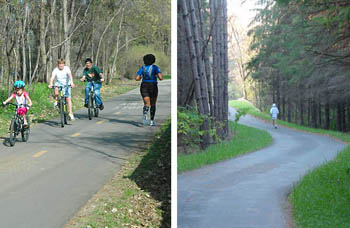
Linking trails can reduce car use
“Linking trails are primarily to get you from one place to another,” Youngquist said. “Many are developed in conjunction with roadway projects, so they’re parallel to the road, but they’re going to get you from one regional park to another.”
Grissman said these linking trails promote exercise and help reduce reliance on cars.
“If there’s a gap in the trail, you’re not going to use it,” Grissman said. “You’re going to get your car and drive there.”
The Minnetrista Regional Trail Search Corridor looks to create a link to the Luce Line State Trail and several regional facilities: Dakota Rail Regional Trail, Gale Woods Farm, Lake Minnetonka Regional Park, Carver Park Reserve and the Lake Minnetonka LRT Regional Trail. It would provide a north/south trail in an area of predominantly east/west routes.
A trail route has not yet been determined, but Three Rivers Park District is scheduled to begin the formal master planning process later this year. The result will determine the trail route and set the stage for future property acquisition and trail development partnerships.
Regional trail use expected to increase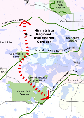
In 2011, the regional parks and trails system had nearly 44 million visitors. Of those visits, about 60% were to parks and 40% to trails. But trail use is increasing, Youngquist said, so with the recent focus on trail development, that disparity will likely balance out in the future.
“It’s looking at equity for people throughout the region,” Youngquist said. “You might not get a regional park, but we can hopefully provide another recreational opportunity through the regional trails and make connections to existing regional parks.”
Currently open to the public are 308 miles of regional trails in the metro area. By 2030, the Council hopes to more than triple that number to 1,000.